In Part 1 [1] of this article, we safely navigated through the Tehuantepec winds, and anchored inside the estuary at Bahía del Sol, where we experienced Pupusa Saturday with Bill and Jean. Moving onward, we are now ready to face the Papagayos, on the way to – or back from – Panama.
The Papagayo Winds
The Papagayo winds funnel through mountain gaps (especially around Lake Nicaragua) from Caribbean highs. Although the hotspot is the southern half of the Nicaragua coast and the Gulf of Papagayo in northwest Costa Rica, the effects of these winds stretch 300 miles offshore. Northeast to northwest winds hit 20 to 50 knots (with gusts over 60) and serve up a nasty, short, steep wind chop.
Seasonality & Persistence
The Papagayo and Tehuantepec winds are both driven by the same winter high-pressure systems, peaking from December through April, and with the strongest blows mid-December to March. While Tehuantepecers arrive as distinct events that can suddenly switch off, the Papagayos are far more constant: they may ease, but rarely disappear completely during the dry season. Expect shorter windows and more day-hopping. The shoulder months (late April to May and October to November) offer the lowest risk of strong gap winds while avoiding the rainy season’s daily squalls and lightning.
Transiting the Papagayo Zone
Day-hop close inshore. Break the trip into 20 to 30 NM bites, staying less than ½ mile offshore or on the 10-fathom (60 ft / 18 m) depth contour where the fetch is tiny and waves play nice. Because you’re in so close, navigation is daylight only, so your hops will be short.
Time the lulls. Winds follow a daily rhythm (quiet mornings, stronger in the afternoon, easing in the evening) but don’t count on the full “off switch” that you get in the Tehuantepec. Sail on any 12- to 24-hour lighter-air window. Popular staging areas are Meanguera (Gulf of Fonseca) or Marina Puesta del Sol (a great place to pause northbound or southbound).
Reef early and have options. Double-reef before things get sporty. Protected bays and marinas in the Gulf of Papagayo are excellent hideouts either way, but the open shoreline works too. Find a sandy shore and drop the hook in 15 to 20 feet of water; the winds will calm the waves and hold you offshore.
On Avant, we rose before dawn and raised the main with two reefs (and felt like cowards doing it). By mid-morning we were considering a third reef. By mid-afternoon we had had enough and nosed into a sandy bit of coast to drop the hook and take the rest of the day off.
Come On Rover [2] relates their passage: “Cruising along with ‘one foot on the beach’ the winds picked up as predicted… consistent mid-to-upper 20s and regular gusts up to 35. As we were VERY close to the beach, the fetch was limited, and the wind waves were completely manageable.” This advice is applicable northbound or southbound.
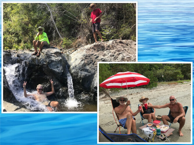
Left: Enjoying a tropical stream in Bahia Santa Elena, Costa Rica with fellow BCA members Greg and Alice from Anduril; Right: A picnic ashore at Samara beach with Greg and Alice.
Costa Rica Highlight
The heart of the Papagayo zone is Costa Rica’s spectacular northwest coast. Southbound crews usually clear in at Playa del Coco, a lively fishing town with supermarkets, restaurants, and easy buses to Liberia for major provisioning. Northbound crews clear out there before heading into the strongest winds.
The Gulf of Papagayo and nearby waters offer several excellent all-weather anchorages:
- Bahía Culebra: spacious and well-protected, with good holding.
- Bahía Santa Elena: stunning and often the calmest spot in the gulf. This is part of Santa Rosa National Park so confirm current access rules. Brief stops without clearing in are tolerated when arriving from the north or south. We spent several days in this deserted and beautiful anchorage.
- Marina Papagayo: this full-service, luxury marina with fuel, repairs, restaurants, and resort amenities offers a welcome (albeit expensive) break from anchoring.
Once past Cabo Santa Elena the winds ease noticeably and the coast becomes more relaxed, with good stops along the Nicoya Peninsula before the long run to Punta Mala (southbound) or as you exit the wind zone (northbound).
The coast of Costa Rica offers fantastic views, beautiful beaches and natural beauty with a side of environmental reserves, so take your time to visit and enjoy them.
South of Costa Rica, the waters of western Panama are little traveled and enchanting. The Isla Secas, Boca Chica, Bahia Honda and Coiba National Park are highlights. Provisioning is scarce, so be stocked up when you arrive. It’s a place you will want to linger.
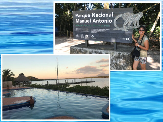
Top: We anchored off Manuel Antonio National Park and swam ashore to enjoy it; Bottom: The pool at marina Puesta del sol in Nicaragua.
Final Leg: Rounding Punta Mala
Punta Mala (“Bad Point” in English; the Spanish were not kidding) marks the western entrance to the Bay of Panama. Strong currents (often 3+ knots, frequently south-setting), huge tides (up to 20 ft / 6 m), confused square waves, and sudden squalls make it the last (southbound) or first (northbound) challenge.
Persistent south-setting current means timing is everything; slack water minimizes chop and foul current.
Southbound (northwest to the Bay of Panama)
Wait at Playa Venao and leave to time your rounding at or just after slack low tide or during the ebb. We spent several nights in Venao waiting for our weather window.
Northbound (Bay of Panama to Costa Rica)
Time your passage to round at or just after slack high tide or during the flood for a helpful push against the south-set current.
Current augmented wave action develops more noticeably in deeper water. We rounded in 50- to 60- foot depths and could clearly see much more wave action in the deeper water. Some crews prefer night passages (lighter winds) if comfortable with shipping and radar/AIS. Freighters converge here for the canal. Bail-out options include heading over to the Las Perlas Islands or tucking into Isla Iguana (holding can be marginal here, with sand over rock/coral).
Panama City Anchorages & Marinas
Once around Punta Mala, the Gulf of Panama opens and the city skyline appears like a mirage as you approach.
- La Playita Anchorage (south side of Amador Causeway): free, often calmest in dry season. There is a modest weekly fee for dinghy dock at La Playita Marina. We anchored in La Playita for ten days, and it was great.
- Las Brisas Anchorage (north of Isla Perico, city side): free alternative; better in rainy season from southerly swell, but it can be choppy with northerlies in dry season. Great view of the city skyline. Dinghy landing at the new ferry dock.
- Balboa Yacht Club: historically popular but effectively closed with an uncertain future; most moorings unavailable.
- Flamenco Marina (at the end of the Amador Causeway): full-service docks, showers, restaurants, short taxi to downtown. Popular for canal prep or final departure.
- La Playita Marina (at the end of the Amador Causeway): full-service docks, showers, restaurants, short taxi to downtown. Popular for canal prep or final departure. Busier than Flamenco, home to many tour boats to the Perlas Islands.
These spots make provisioning, laundry, and canal-agent meetings painless in either direction — and the city lights at night are worth it.
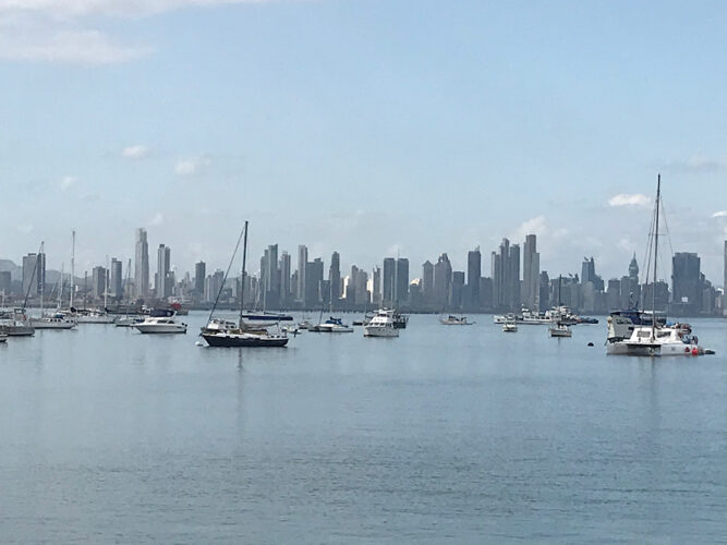
The Las Brisas anchorage in front of the Panama City skyline.
General Passage Tips
In addition to this area-specific information, here are some general tips for navigating the Central American Pacific Coast:
- Forecasts: model-based forecasts (GRIBs, most automated models) often underestimate severe weather events like hurricanes, Tehuantepecers, and Papagayos. Check against human intelligence from a weather router or NOAA/NHC forecasts.
- Best windows: Shoulder months (late April to May and October to November) give the lowest gap-wind risk and avoid the worst of the rainy-season squalls.
- Weather resources: GRIBs, satellite, cruiser networks (Ocean Posse, WhatsApp groups), NOAA/NHC.
- Boat Prep: Bomb-proof ground tackle, easy reefing, stout sails, reliable engine, and adequate fuel are a must.
- Provisions: Stock up, as you are likely to be boat bound in the Papagayo area and there are few spots to provision in western Panama.
- Currents and Navigation: Coastal current usually helps southbound, but opposes northbound; mind the tides at Cabo Santa Elena (slack rounding) and especially Punta Mala.
- Safety: Check current anchorage advisories. The coast rewards you with surfing, whales, monkeys, dolphins and sloths (my spirit animal). Petty theft can be an issue, particularly in Costa Rica.
- Special Equipment: nothing really, but a set of cycling glasses (the close-to-your-face wrap-around style) are great to have in the high winds!
Reliable forecasts, patience, the hug-the-beach trick (distance off or depth contour), respect for the seasons, and the option to bail out for inland adventures (or a CA-4 road trip fueled by pupusas) when the weather is wrong turn this coast from feared to fondly remembered in both directions. The scenery is spectacular, the gap winds are beatable, and the memories — whether from a T-pecker that never showed, a hardware-store shopping spree, a Flor de Caña rum tasting, or finally slipping around Punta Mala at slack tide — are priceless. Plan conservatively, stay flexible, and enjoy the ride.
Fair winds (the light ones)!
*Featured image: Waiting out a tropical rain shower at Banana Bay Marina’s restaurant while in Golfito.